Travels with
Lois and Jason
Micronesia Snorkeling
(and WWII History)
May 14 – 27, 2010
 Where in the
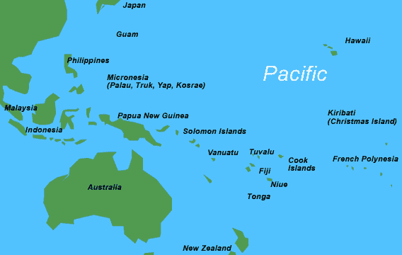
world is Micronesia? Of all the places to go, why go there? How did we ever pick this trip?
Where in the
world is Micronesia? Of all the places to go, why go there? How did we ever pick this trip?
Micro (meaning small) nesia (islands) is a
collection of thousands of small islands in the western Pacific
Ocean. We visited three: Yap, Palau, and Peleliu, and passed
through one (Guam) on the way there. Except
for Guam, we had never heard of the other islands. So, how is it we ended up on one of the most
adventurous of our trips in such an unknown and remote place.
In making an online donation to World Wildlife Fund we spotted their
travel page, and there was a description of “Micronesia Snorkeling
Adventure.” We had figured that the
snorkeling in the Maldives just couldn’t be topped. Well, we
were wrong. The web description was
very appealing. It advertised that
there was world class snorkeling in terms of variety of fish and
coral, and the trip was designed for experienced snorkelers (i.e.,
those that could snorkel for an hour or more at a time). We felt intrigued and qualified. We hadn’t been on a trip for almost 18
months, so we decided to go!
But, it was a challenge figuring out where the trip was going.
A quick map search on the internet shows Palau and Yap as dots in
the middle of the Western Pacific. (It took lots of
magnification to make the dots big enough to see.) Yap is 500 miles
southwest of Guam, and Palau another 280 miles (and one more time
zone) southwest. This of course assumes you know where Guam is
(which we really didn’t). Guam is about 3300 miles west of
Hawaii and 1500 south east of Japan. Note map is not to
scale.
Of greater importance is that Palau was seen as a strategic
location, being only 600 miles from the Philippines and 1300 miles
from Okinawa. We’ll discuss why this is important later in our
story.
Our trip turned out to be three different stories: snorkeling,
the culture of Yap, and an introduction to the war in the Pacific
during World War II.
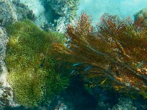
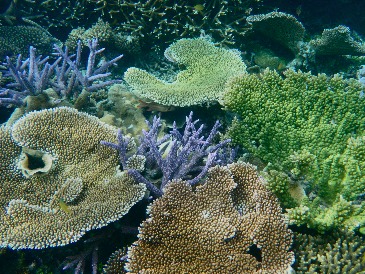
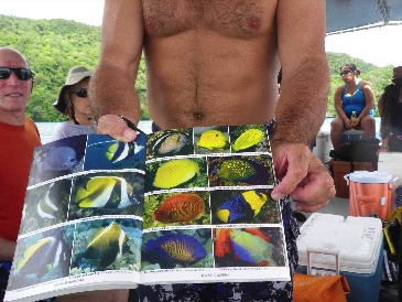
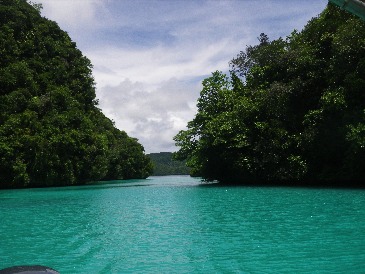
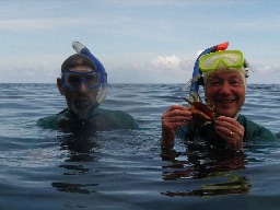
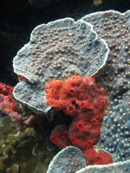
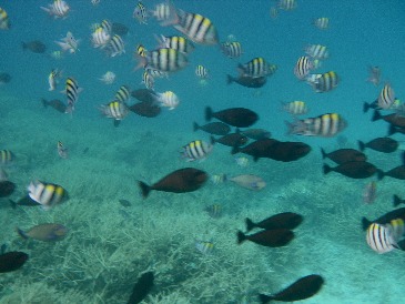
Snorkeling
We wondered if any snorkeling trip could match our incredible trip
to the Maldives. We doubted it. But we were wrong. Our
Palau trip was by far the best snorkeling we’ve ever done anywhere,
even superior to the Great Barrier Reef.
|
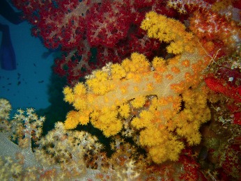
Journal
entry for May 22: Yesterday we saw so many beautiful and
varied fish that we thought we were swimming in an aquarium. Today we really swam in an
aquarium. Flower gardens of
incredible beauty; coral
baskets of enormous size and layered, like pedals of a
rose.We saw basket coral inside basket coral, climbing the
walls of a rock island,
appearing like rose pedals of enormous size (several feet
across). While the coral was
all basically brown-gray, it was the amount and arrangements
that made this such a special visit. |
 |
|
|
|
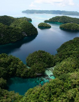
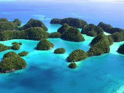
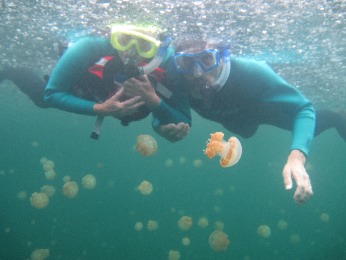
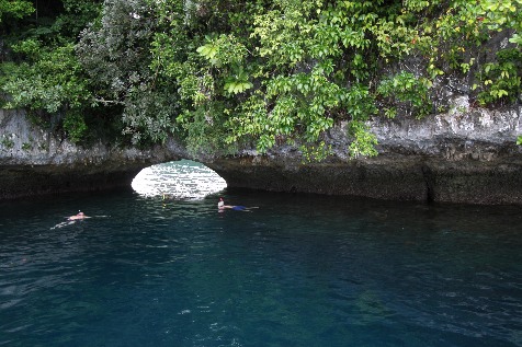
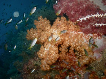
When you look at the top of the ocean it is hard to believe there is
an entire world out there, and we saw it on this trip as never
before. What made it so special was a
combination of factors: in addition to its natural beauty of Palau’s
Rock (limestone) Islands, it has a huge variety of very beautiful
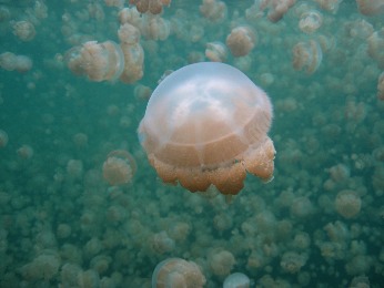
fish and coral. We swam in Jellyfish
Lake, a completely enclosed saltwater lakes surrounded by mountains
of limestone a 100 feet high, where the water source was the water
percolating through the limestone at high and low tide. We saw tiny
tropical fish and enormous sharks and manta rays.
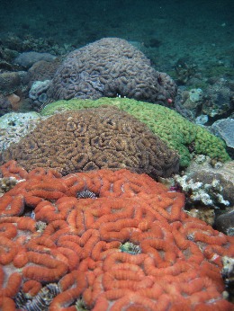
We saw table coral which could
easily seat 12, and fan and brain coral of every conceivable color.
And bringing it all together and making it all come alive was our
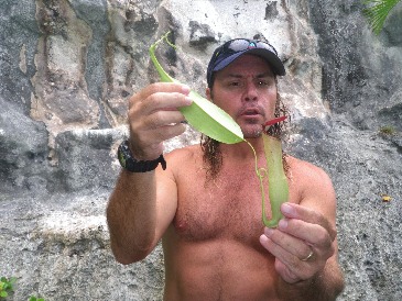
guide, Marine Biologist Ron Leidich. Ron pointed out and explained everything, and
selected each outing to specifically match the tides and
currents.
Ron
took pictures throughout our trip, frequently free diving to take
close ups of the fish and coral. He very generously provided
us with a disk with all the pics, many of which are included in our
story.
At our first meeting we were told that we'd be snorkeling according
to the tide. This was a new experience
for us. In the past the snorkeling boat
left at 10 and returned at noon or left at 2 and returned at 4. But we were told the tides make all the
difference in terms of which fish were to be seen and which lagoons
were accessible. In fact, we were told
the entire trip was scheduled to optimize a tidal flow so that we
could experience a saltwater “water fall.” As
tidal
waters flow out of an enclosed marine lake, they cascade into
Mandarin Fish Lake. It was very strange
to be snorkeling and hear the sound of flowing water like a river. But there it was, cascading over rocks in
front of us. And it is most dramatic at
maximum high tides, just when we were scheduled to be there!
We met our boat each morning at 8:30 and were scheduled to returned
to the hotel dock at 4:30, but usually arrived about 5, or 5:30, or
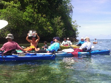
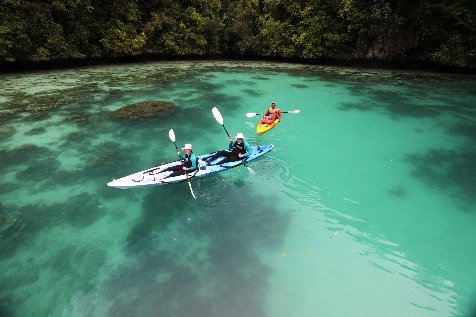
whenever we were snorkeled out! Being in a group of only 13
with a personal guide made it a very flexible and enjoyable
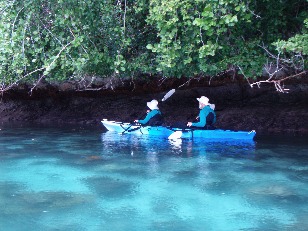
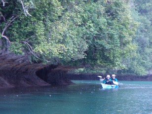
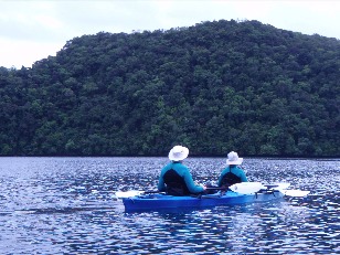
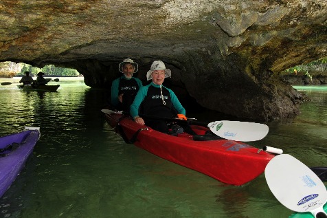
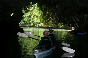
experience. Our days consisted of snorkeling, kayaking,
saltwater lakes and lagoons, karsts, caves, and rain.
We think more rain fell on us while we snorkeled Jellyfish
Lake than falls in an entire year in LA. At
least it felt that way! And it didn’t
hurt the visibility. In fact, sometimes
the full sun was too bright and washed the coral colors out – like
over exposing a picture. Fortunately
the weather was constantly changing with rain showers every day.
Journal entry for May 25: Today we
snorkeled Disney Lake. We entered through a tunnel at medium
tide so our feet wouldn’t scrape the bottom and our heads not hit
the top, and most importantly, the current was manageable. At low tide you can "limbo kayak" into the
lake, through the tunnel, but our "young" backs don't quite limbo
they way they use to, so we did the snorkel option at mid-tide. Anyhow, Disney Lake, an "old growth" coral
bed, is a salt water lagoon totally surrounded by high limestone
walls, with the only entrance being the tunnel, which is about 15
feet wide and 5 feet high. At high or
low tide, the current through the tunnel makes it very difficult to
pass. It is called Disney Lake because of the spectacular colors of
the coral.
 |
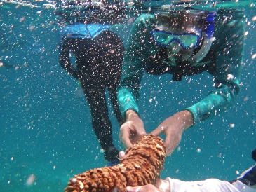
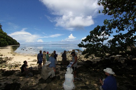
We
visited a bay called the Milky Way. The bottom of the bay
consisted not of sand but of white limestone mud, which gave
the water a “milky” sheen. Ron
dove to the bottom and brought up hands full of the muck and
we gave ourselves facials. Great
fine fun!
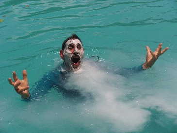
We snorkeled at Blue Hole. Four
holes that were carved in the ocean like the grand canyon
but with arches, corals, and
numerous fish. When you looked
down the holes from the surface, the water appeared to be a
dark rich blue and it was just beautiful. This picture
was taken by Ron from deep in the hole of all of us "sky
diving."
|
|
 |
|
|
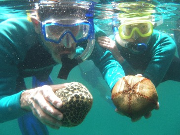
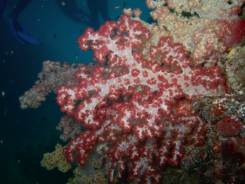
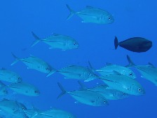
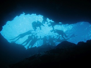
We snorkeled Soft
Coral Arch to view the spectacular soft
corals. What a treat!
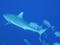
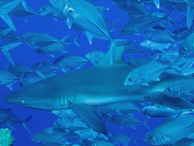
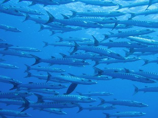
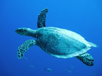
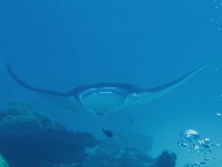
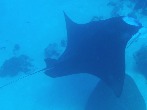
And on a couple of occasions, we snorkeled the outer reef. Here we’d be two feet above the coral but
then swim off the coral to a 200 (or was it 2000) foot drop. All kinds of big fish liked these walls,
including barracuda, black and white tip sharks, sea turtles, and of
course manta rays. (Ron, free diving, took all these great
pictures.) And of course, an
uncountable number of smaller tropical fish of every hue and color. It was spectacular. And one
time at the outer reef we simply drifted with the outgoing current
for about an hour. It was an unusal
experience being swept along, and lots of fun! The boat
followed us and picked us up when we were ready to get out.
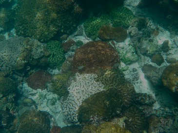
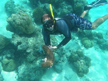
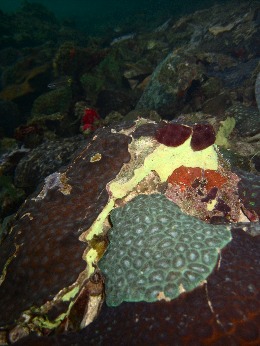
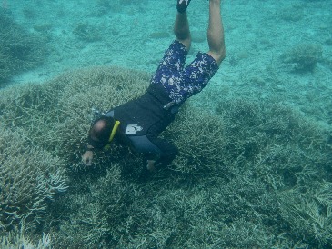 Tragically
the coral reefs of Palau are threaten by the crown-of-thorns
starfish. This starfish eats coral, and plays an important
role in the natural sequence of events in maintaining coral
diversity. However, pollutents, particularly from sewage
plants, have caused the population of crown-of-thorns to thrive and
mushroom. The crown's natral predators, the Giant Triton (a mollusc) and the harlequin shrimp, are both popular food
items with locals, and their populations are in decline. So
the crown-of-thorns are now literally wiping out entire coral
reefs. Ron has undertaken a campaign to eliminate these
starfish, and to-date has been very successful when he arrives in
time. He took us to areas of devastation where entire coral
beds are dead, and there are no fish. The fish need the coral
for food and shelter. And he showed us some of his success
stories where he has purged an area in time for it to begin to heal
itself or actually stopped an invasion that had begun. To
eliminate this starfish, Ron dives down, digs them out of their
hiding place, and makes mince meat of them. When chopped into
tiny pieces the arms cannot reproduce. When Ron undertakes
the eradication of a large number in one area (as in hundreds at a
time), he spears, bags, and then dumps them in the middle of a
Rock Island. What is incredible is that Ron has taken on this
challenge as a volunteer, and finances the work himself.
Tragically
the coral reefs of Palau are threaten by the crown-of-thorns
starfish. This starfish eats coral, and plays an important
role in the natural sequence of events in maintaining coral
diversity. However, pollutents, particularly from sewage
plants, have caused the population of crown-of-thorns to thrive and
mushroom. The crown's natral predators, the Giant Triton (a mollusc) and the harlequin shrimp, are both popular food
items with locals, and their populations are in decline. So
the crown-of-thorns are now literally wiping out entire coral
reefs. Ron has undertaken a campaign to eliminate these
starfish, and to-date has been very successful when he arrives in
time. He took us to areas of devastation where entire coral
beds are dead, and there are no fish. The fish need the coral
for food and shelter. And he showed us some of his success
stories where he has purged an area in time for it to begin to heal
itself or actually stopped an invasion that had begun. To
eliminate this starfish, Ron dives down, digs them out of their
hiding place, and makes mince meat of them. When chopped into
tiny pieces the arms cannot reproduce. When Ron undertakes
the eradication of a large number in one area (as in hundreds at a
time), he spears, bags, and then dumps them in the middle of a
Rock Island. What is incredible is that Ron has taken on this
challenge as a volunteer, and finances the work himself.
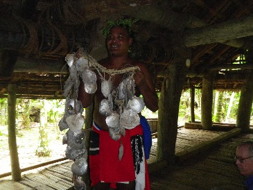
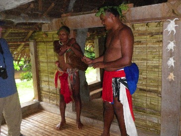
Yap Culture
Our first day in Micronesia was a very limited introduction to
Yapese culture. We visited a village community house and
learned about stone money, visited a traditional men’s house to
learn of the working of a village, and attended a presentation of
traditional dances.
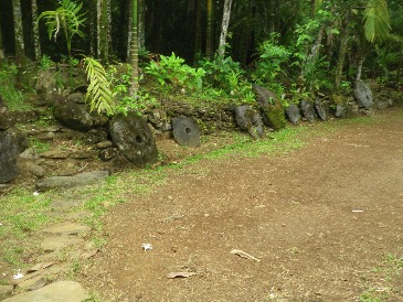
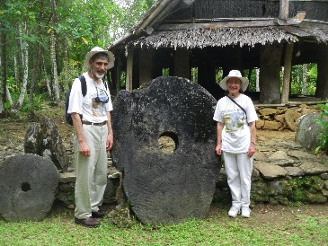
Stone money, carved from limestone on Palau (300 miles away), and
transported via bamboo rafts over open water without navigational
technology, are a defining aspect of traditional Yap culture.
Limestone as such does not exist in Yap. The stone money
weighs hundreds, and in some cases, thousands, of
pounds. It is a few feet to as large as 12 feet in
diameter and remains in front of each village’s community
house. Its value depends upon its history, how it is used (as
in marriage arrangements), and varies in exchange with other
villages.
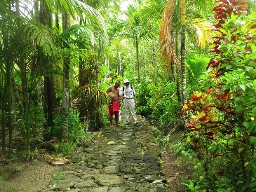
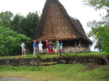
Originally, Yap had a main path made of stones circling the island
and each village had a stone path leading from the main path to
their villages. The main stone path around the island is now paved,
but some of the village paths still are in use. We were taken down
one of these stone paths and asked to carry a fern branch with the
leaves in front to indicate we came in peace. The village
community house was the first structure you'd see at the end of the
village path and this is where the village stone money is
kept. We saw additional paths leading from the community house
and we were told those lead to where the people lived, but we were
not allowed to walk those paths so we never saw their homes.
We were taken to another village to visit an extremely well
preserved traditional men’s house. The chief of this village
recognizes the potential of tourists and welcomed us. They displayed
the plant weaving and handiwork of the women and told us they were
for sale. We were told that you always need to ask permission
before taking anyone's picture. When we visited his village we
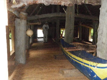
were free to take all the pictures we wanted. In traditional Yap
society, the men's house is where the boys were taught to be men,
where the men gather to go fishing and do battle with their
neighbors, where the village business was conducted. It was
always near the sea. We had trouble gathering info on the
women’s houses, which apparently no longer exist. What we did
learn was that they were always just on the outskirts of the
village, where women went when they had their periods and to deliver
their babies.
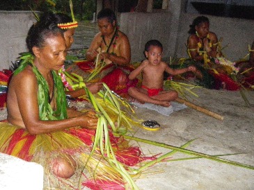
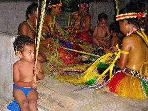
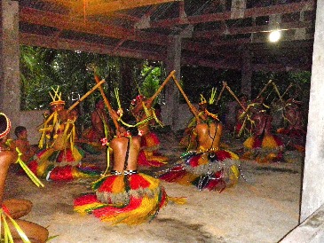
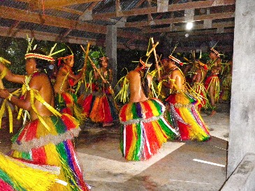
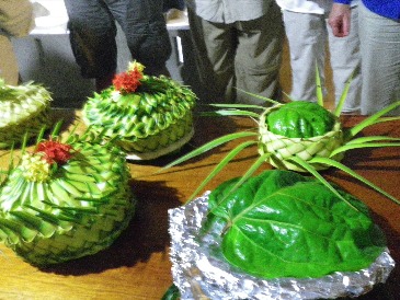
In the evening we attended a dance presentation, which also included
the laying out of a traditional banquet of foods in baskets made by
the women of that village. The dishes were mainly fish and
taro (a root vegetable and staple in their diets). The dancers
were all from the same village (they seem to have village dance
competitions). We saw several traditional stick
dances. The group was mostly women (ranging in age from very
young to one who could easily be a grandmother). In Yap
culture, bare breasts are acceptable, but bare thighs are not.
The instruments were drums, voices and sticks.
The van used by our tour only held 10 people, so we chose to ride in
the pickup truck that held 3 people so it was easier for Jason to
get in and out. This gave us a chance to speak extensively
with our driver who shared quite openly with us about his
country. Here are some of the things he told us:
The people of Yap still live in their villages, and for the most
part live off the land. (According to the CIA World Factbook ,
“Economic activity consists primarily of subsistence farming and
fishing.” Per capita income in Yap is about $2000.)
There is clearly a conflict over maintaining traditions. We
saw a few of the men wearing the traditional cloth, but everyone
else wore western clothes. Our driver told us his daughter,
now a high school senior, wants to go to the States for college, and
it would be unlikely that she would return to Yap. He said he
has electricity at his house, but no television, but his daughter
uses a computer at high school.
We were told there are no traditional or native religions, the
majority of people are Catholic, and that some people were
Seventh-day Adventist or Mormon. We saw a couple of
Seventh-day Adventist schools.
There are no traffic signals on the entire island of Yap.
Tragically a Yapese boy serving in Afghanistan was being brought
home for burial and as we came in on our boat we heard a whistle
blowing constantly. There was a traffic jam as so many were
going to the funeral and they had a policeman directing
traffic. We were told that was an highly unusual event.
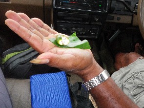 Many people
we encountered seemed addicted to “betel nuts.” Remember the
song from South Pacific, “Bloody Mary is the girl I love…she is
always chewing betel nuts…” Well, betel nuts are addictive and
are a mild stimulant. The seeds of an areca palm tree are
wrapped in betel leaves and chewed. Many men keep their
thumbnail very long and sharp so they can use it to open the seeds.
Many people
we encountered seemed addicted to “betel nuts.” Remember the
song from South Pacific, “Bloody Mary is the girl I love…she is
always chewing betel nuts…” Well, betel nuts are addictive and
are a mild stimulant. The seeds of an areca palm tree are
wrapped in betel leaves and chewed. Many men keep their
thumbnail very long and sharp so they can use it to open the seeds.
Finally, here’s a tiny bit of Micronesian history as it helps to
understand some of what we saw. This is a history of
occupation. Micronesia has had four external rulers: the
Spanish, the Germans, the Japanese, and the Americans. All
shave left their mark.
The Spanish occupied and converted vast reaches of the Pacific to
Catholicism during the Age of Discovery during the 16th
century. In 1899 (to pay for the Spanish American War), Spain
sold its Pacific islands to Germany. Japan joined the Allies
in World War I and as a spoils of war was given the German
territories in the Pacific, including Micronesia. During WWII, the
US captured the islands and they remained a part of a US Trust
Territory until November 3, 1986, when the Federated States of
Micronesia became independent. Yap has been open for tourism for
barely 20 years, with diving (and snorkeling), and WWII history
buffs its major attractions. The government of Yap is trying
to expand the offering with the preservation of traditional Yap
culture.
Of all our travels, Yap has to rank at the top in terms of being
least tourist oriented, a true haven for those looking for native
art and culture, but a real frustration for those seeking a tourist
tee shirt. It was quite amazing to be in a country where there
were NO tourist shops and no one selling goods on the street. When
we went to the shopping area in the capitol Colonia (which is also
the only town on the island), the “supermarket” (which was
government owned) had a section with a few things one might consider
for tourists. We actually found a tee shirt we liked on a
manikin, but they were sold out and had no idea when they would get
more. Our guide then took us to a privately owned
market. It too clearly only focused on the needs of the local
population. Interestingly at this market, everyone left their
shoes on the veranda outside and went in barefoot. We were
told this was a left over tradition from the Japanese
occupation. Also, almost everyone’s grandparents spoke
Japanese, also a result of their time under Japanese rule. Now
of course, everyone speaks English. One of the men (age about
40) at our hotel told us he learned US history in school, not Yap
history.
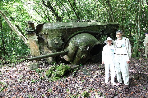
Our Introduction to the War in the Pacific
The last thing we expected on this trip was a World War II history
lesson and it was quite an eye opener. We had no idea we were going
to one of the most critical, and controversial battle grounds of the
war in the Pacific. We visited the air
strips which were bombed, walked the beaches of the landing forces,
saw remains of both Japanese and American tanks and guns, and
visited Japanese caves and bunkers and heard stories of horrific
events and matching bravery.
We were really ignorant of the war in the
Pacific other than a few names like Pearl Harbor and Iwo Jima. We knew nothing of the significance of
the Battle of Midway which was the turning point taking the US
from a defensive to offense position, and the strategic
importance, and later controversy, over the Battle of Peleliu. Peleliu was a strategic Japanese base
which allied commanders felt must be captured before they could
attack the Philippines. But the
Philippines were attacked before Peleliu was captured.
We were told that the Japanese fire bombed the
redwood forests in Oregon, but we didn’t believe that really
happened. But The LA Times September 15, 1942 headline read “Report Oregon
Bombing, ” and gives fascinating eyewitness accounts. In our subsequent search, Wikipedia
describes five Japanese attacks on North America during WW II. For the first time we can understand why the
country panicked and put loyal Japanese Americans into
interment camps.
On our first day in Yap we visited the location of the Japanese
airfield and learned of a mysterious Japanese-American spy (no one
to this day knows who it was). The
Yapese felt the spy saved the island from destruction as the spy
marked the Japanese airfield runway with the message, written very
large in English, that the Japanese were waiting for orders to
surrender. Click here
to see the incredible picture.
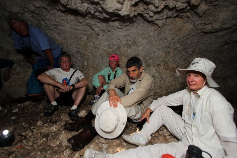
In Palau we visited the island of Peleliu,
about a one hour boat ride from our hotel. The
Battle of Peleliu was the most costly battle ever fought by the US
Marines in their entire history (with a 34.3% casualty rate). Our first stop at Peleliu was at the
1000 man cave, a place where Japanese soliders remained while the
US bombed the island for days. Before
entering the cave, Terry, one of our fellow travelers, asked to
share some information with us. Terry said he was a former Marine
serving during the Vietnam War, and at one point during boot camp
all the men were taken to a hut where a colonel told them of the
Battle of Peleliu. Terry told us that
where we were was considered scared ground to Marines. It was very chilling. It
made
what we saw so much more personal and meaningful.
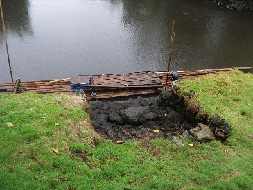
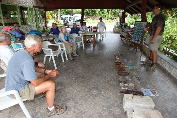
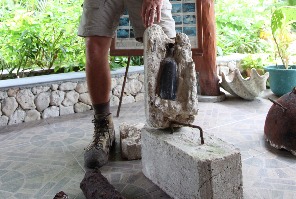
We spent about four hours touring Peleliu and then after lunch
Stephen Ballinger, Operations Director for Cleared Ground Demining,
told us of his work in clearing Palau of old unexploded
ordnance. He showed us bombs, grenades, and booby-trapped
things (the brick in the picture) that he collected (and disarmed)
in just the last week. The Marianas
Variety, a local newspaper for Micronesia, had an article
about Steve’s important work on October 7, 2009.
We find war history very emotionally
challenging. One evening Ron gave a lecture on the history of the
Pacific which explained many of the actions of Japan between 1853
(when Commodore Perry invaded Japan) through to 1941 and Pearl
Harbor. Although in the past we have
shied away from war movie and programs, we realized that there is
considerable history for which we are totally unaware and need to
become more cognizant. With this
trip, our education has begun.
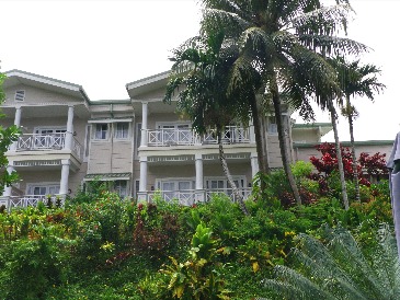
Accommodations
We can't end without a note on our hotels. Our first two
nights were at the Traders’ Ridge Resort on Yap. This hotel is
on a hilltop overlooking a bay. We had a balcony we couldn't
use because of the heat, humidity and rain (although we did have a
nice view).
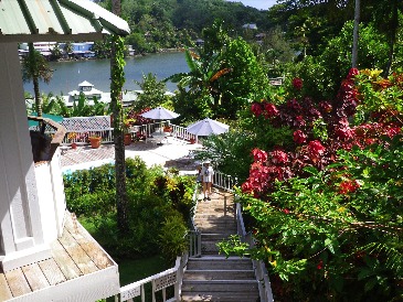
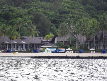
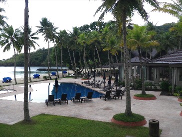
The Palau Pacific Resort room had a view of the bay and restaurant
and, and was very comfortalbe for our 8 night stay. The
grounds were lovely and included a large saltwater fish pond with
turltes, sting rays and many of the fish that we had seen
snorkeling.
Photo journalist: Lois Frand
Writer:
Jason Frand
Editor:
Lois Frand
You can
reach us via email at Jason
or Lois
June 11, 2010