|
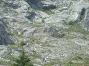
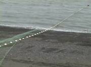
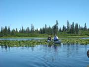
Note hikers at middle bottom
|
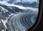
The hike that
was scheduled for our third day in Glacier Bay was to a
ridge high above the water to view the Riggs
Glacier. The route is shown in the picture to the
left.
Glacier Bay
is a wilderness park with no roads nor man-made
trails. All our hikes followed animal trails, narrow
paths created by bears over the eons. For some
routes, the animals followed the same path and over time
the plants simply got mashed down and created a
trail. We were going to just go part way along
one of these trails, an easy scramble according to Kimber,
but far enough to see the Riggs Glacier across its
inlet. All our shipmates were going to climb
to the top of the ridge.
|
|

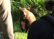
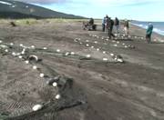
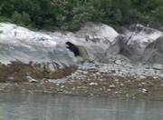
Here comes de bear!
|
A stream came into the bay near where we were anchored and
our landing area was just beyond it. Once on the beach
we divided into two groups and the fast group began their
ascent. But a few minutes after we separated, these
well laid plans were disrupted by the sound of fish
splashing in the water.
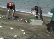
Salmon, for some unknown reason, leap from the water.
Kimber said it may simply be “jumping for joy when they
smell their birthing stream.” Whatever the reason, the
bears in the forest hear the splash and it brings them to
the water’s edge to fish.
|
|

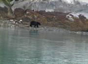
Rock behind Jason (Lois is still there!!!)
was refuge from grizzly charge
|
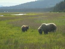
We were now in Glacier Bay,
not Lake Clark. The bears here may very occasionally,
if ever, see a human. They don’t know what we
are: friend, foe, food or fluff. Bear protocol
says that if you meet a bear you are to bunch together to
look bigger than the bear, speak softly, and back away to
give the bear space. The Park Service wants bears to
see humans as non-entities to be ignored.
Well, Kimber, Lois and Jason are on this beach and the
salmon are jumping for joy and down the mountain comes this
adolescent male grizzly bear, maybe 500 pounds of teen
spirits. He quickly swam the stream and Kimber says,
“I recognize that bear. He charged me last year.”
Next thing we know she has us scrambling up a big rock
behind us (pictured left), where there was definitely no
bear food around. |
|

The grizzly charger having
a very berry feast
|
Kimber afterward told folks
that “Jason forgot he was blind the way he went up that
rock!” In Lake Clark, we were only a few feet
from huge bears and never felt threatened. But now,
here we were 50 yards away, and our hearts racing - we were
under attack. The bear came out of the stream and ran
up the beach, stopped maybe 10 yards away, smelled the air
and looked over the situation. That was a real heart
stopper! The bear then turned and started eating
berries. Kimber meanwhile was on the walkie-talkie
with the other group, telling them to come down so we could
make a “bigger” group and everyone would be safely on the
beach, not on a high narrow bear path. Once we were on
our rock and the bear was eating, she told them they could
go ahead with their hike. We spent the next hour
watching the bear eat. Once the bear left, the rest of
the group came safely down the mountain and joined us and
the skiff, which had been called to wait off shore, and took
us back to our boat. |


 not only shocked
and thrilled us, but left us craving for more.
not only shocked
and thrilled us, but left us craving for more.


 cruise, along with
the five crew members. The boat was once the USS Observer
commissioned in 1941 as a mine-sweeper, a small, all wood, slow (7
knots max speed) boat, and decommissioned in 1945. It was
perfectly designed for an intimate cruise past some of the world’s
most beautiful fjords and glaciers. Because of its size, we
were able to go into inlets and side channels larger ships could not
access. Also, there were daily kayak paddles to move even
closer to rookeries, tide pools and glaciers (we did two of these),
and rock scramble hikes so we could truly experience the ice (we did
two of these). With six days to explore Glacier Bay, we felt
we saw all that could be seen from the sea.
cruise, along with
the five crew members. The boat was once the USS Observer
commissioned in 1941 as a mine-sweeper, a small, all wood, slow (7
knots max speed) boat, and decommissioned in 1945. It was
perfectly designed for an intimate cruise past some of the world’s
most beautiful fjords and glaciers. Because of its size, we
were able to go into inlets and side channels larger ships could not
access. Also, there were daily kayak paddles to move even
closer to rookeries, tide pools and glaciers (we did two of these),
and rock scramble hikes so we could truly experience the ice (we did
two of these). With six days to explore Glacier Bay, we felt
we saw all that could be seen from the sea.


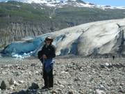
 Touching Reid Glacier


 instead. The channel
was choked with icebergs, so Captain Steve took us to the far side
of the channel, over a mile away from the face of the glacier, to
get through the icebergs. We made our way up the channel and
reached about the mid-point of Margerie and started steering toward
the face when a glacial wind began to blow. This wind occurs
when conditions are right and is caused by the temperature
difference between the air in contact with the surface of the
glacier and air away from the glacier which is warmer. It was
a strong, cold, artic wind. It quickly cleared all the
icebergs in front of the glacier, but also prevented us from getting
as close to the glacier as we had hoped because of the strength of
the wind. But the wind didn’t stop us from hearing the
crackling of the ice as it splintered and fell. These pieces
appeared to be falling onto the glacier’s surface which we could not
see.
instead. The channel
was choked with icebergs, so Captain Steve took us to the far side
of the channel, over a mile away from the face of the glacier, to
get through the icebergs. We made our way up the channel and
reached about the mid-point of Margerie and started steering toward
the face when a glacial wind began to blow. This wind occurs
when conditions are right and is caused by the temperature
difference between the air in contact with the surface of the
glacier and air away from the glacier which is warmer. It was
a strong, cold, artic wind. It quickly cleared all the
icebergs in front of the glacier, but also prevented us from getting
as close to the glacier as we had hoped because of the strength of
the wind. But the wind didn’t stop us from hearing the
crackling of the ice as it splintered and fell. These pieces
appeared to be falling onto the glacier’s surface which we could not
see.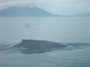 Our last day in Glacier Bay
was spent whale watching. Our hope was to see a breaching
whale. We saw more tails than we could count, and one whale
came really close to the boat, but alas, seeing a whale leap from
the water to return with a mighty splash will have to wait for
another time.
Our last day in Glacier Bay
was spent whale watching. Our hope was to see a breaching
whale. We saw more tails than we could count, and one whale
came really close to the boat, but alas, seeing a whale leap from
the water to return with a mighty splash will have to wait for
another time.